When you use NRTK (Network Real-Time Kinematic) positioning, you rely on your operator’s reference stations. NRTK technology theoretically offers an accuracy of 1 to 2 cm referenced in the current coordinate system. But there’s one condition to this performance: the reference stations must be perfectly stable in all three dimensions.
Drag
- The stability of GNSS stations
- The stability of GNSS stations
- The stability of GNSS stations
- The stability of GNSS stations
- The stability of GNSS stations
- The stability of GNSS stations
- The stability of GNSS stations
- The stability of GNSS stations
- The stability of GNSS stations
- The stability of GNSS stations
The stability of GNSS stations
Scroll to explore
GNSS station stability:
the invisible factor that directly impacts your measurements
For measurement experts, the quality of GNSS positioning is non-negotiable. A drift of just a few centimetres can compromise an execution plan, a land survey or the installation of a structure.
However, there is one element that often escapes the control of professionals: the geodetic stability of reference stations…
…With NRTK, your final accuracy rests directly on this base. If the station moves, the drift is propagated and amplified to your receiver.
That’s why TERIA has made this stability a fundamental requirement from the outset, in collaboration with IGN!
A real case study from the TERIA network:
the Île-Bouchard station
Focus on the ILBO reference station, located at Île-Bouchard near the Vienne river.
The behaviour of this station perfectly illustrates the importance of continuous geodetic monitoring.
The time series below, calculated byIGN, represent variations in the position of the antenna phase centre in the RGF93 reference frame.
Each blue dot corresponds to 24-hour data processing:
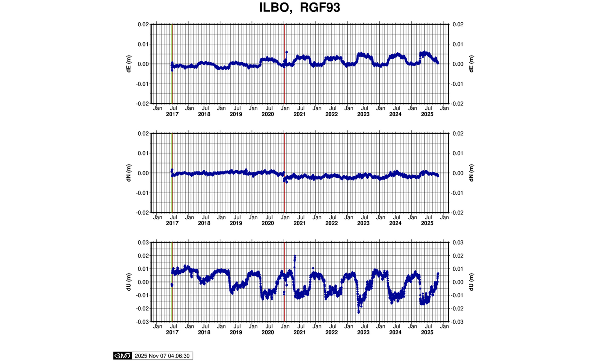
- dU (Up) – Vertical variation :
Positive values = surrection; negative = subsidence.
This is the component most sensitive to geotechnical phenomena (clay swelling, variations in the water table, differential settlement). - dE (East) – East-West movement:
Positive values = eastward movement; negative = westward movement.
This component reveals lateral tectonic or structural stresses. - dN (North) – North-South movement:
Positive values = northward displacement; negative = southward.
Useful for detecting structural landslides or ground movements.
Note: The vertical red line marks the update of the IGN coordinate system at metropolitan level
(transition from RGF93 v2 → v2b).
Diagnostic : un phénomène géotechnique cyclique
Sur le site d’ILBO, le comportement de la composante verticale dU montre clairement des cycles annuels de gonflement et dégonflement atteignant jusqu’à 3 cm d’amplitude. Ce phénomène bien qu’anormal est typique des terrains argileux soumis aux variations saisonnières de la nappe phréatique.
Ce type de mouvement peut également expliquer certains désordres observés localement, comme l’apparition de fissures dans les bâtiments, un signal d’alerte pour les professionnels du bâtiment et du génie civil.
Réaction immédiate de TERIA
Grâce au monitoring permanent combiné à des observations de longues périodes des stations, l’équipe d’ingénieurs TERIA a détecté cette instabilité dès la confirmation des premiers signes.
Pour protéger les utilisateurs, TERIA a immédiatement :
- Diagnostiqué l’origine géologique du mouvement,
- Doublé la station sur un autre site géologiquement stable
- Redirigé automatiquement le service NRTK vers la nouvelle station
Result:
no user has suffered any impact on its absolute accuracy.
To find out more: Discover how the TERIA network was able to detect the birth of an underwater volcano in Mayotte by observing the movements of the permanent stations HERE
Did you know?
Collaborativenetworks do not guarantee accuracy or availability.
4 frequently asked questions
you ask us
in customer service and training
1. Les stations CORS bougent-elles ? De quel ordre est le mouvement ?
Oui, si elles sont installées sur des sites mal choisis ou avec des infrastructures inadaptées, le mouvement peut atteindre plusieurs centimètres par an.
Les facteurs aggravants :
- Sols argileux sensibles aux variations hydriques
- Proximité de nappes phréatiques fluctuantes
- Fondations insuffisantes ou inadaptées
- Structures de bâtiments instables (bois, structure métallique, …)
En revanche, si les sites sont choisis avec minutie et que l’infrastructure respecte les standards géodésiques, le mouvement résiduel peut être réduit à
< 5 mm/an, correspondant au niveau de la précision du système de référence.
2. Si elles bougent, ma précision est-elle impactée ?
Absolument. Chaque mouvement de l’antenne de référence vient s’ajouter à votre budget d’incertitude.
Exemple concret : Un déplacement de 5 cm de la station peut transformer votre précision annoncée de 2 cm en une incertitude réelle de 7 à 8 cm (sans même évoquer l’incertitude additionnelle de votre propre récepteur GNSS).
Pour des travaux d’implantation, des levés cadastraux ou des plans de récolement, cette dégradation peut avoir des conséquences juridiques si elle n’est pas détectée et corrigée.
3. Suis-je informé de ces mouvements ?
Rarement. De nombreux opérateurs ne disposent pas de ressources suffisantes pour assurer une surveillance continue. Et même lorsqu’ils détectent des anomalies, l’information ne parvient pas systématiquement aux utilisateurs. Pire encore, les anomalies ne sont pas toujours corrigées et c’est à l’utilisateur de les détecter pour en informer l’opérateur réseau.
4. Quelle garantie ai-je sur la qualité des stations ?
C’est là que les différences deviennent criantes :
- Les réseaux gratuits (bien souvent communautaires) n’ont aucune obligation contractuelle de garantir un niveau de précision ou une disponibilité.
- Certains opérateurs privés effectuent des contrôles internes, mais ceux-ci ne constituent pas un engagement de qualité opposable en l’absence de certification par des audits externes indépendants.
What not to do:
The criteria for a professional-quality installation
Not all CORS installations are created equal. Here are the criteria that make the difference between an amateur station and a professional geodetic infrastructure:
❌ What to avoid
- Wooden building (deformation, thermal expansion, bending under snow load)
- Metal roof (GNSS multipath, significant thermal expansion)
- Antenna without choke ring (increased sensitivity to multipath)
- Low-cost antenna (large variation in phase centre as a function of azimuth and satellite elevation)
- This type of installation is often found in free or low-cost networks.
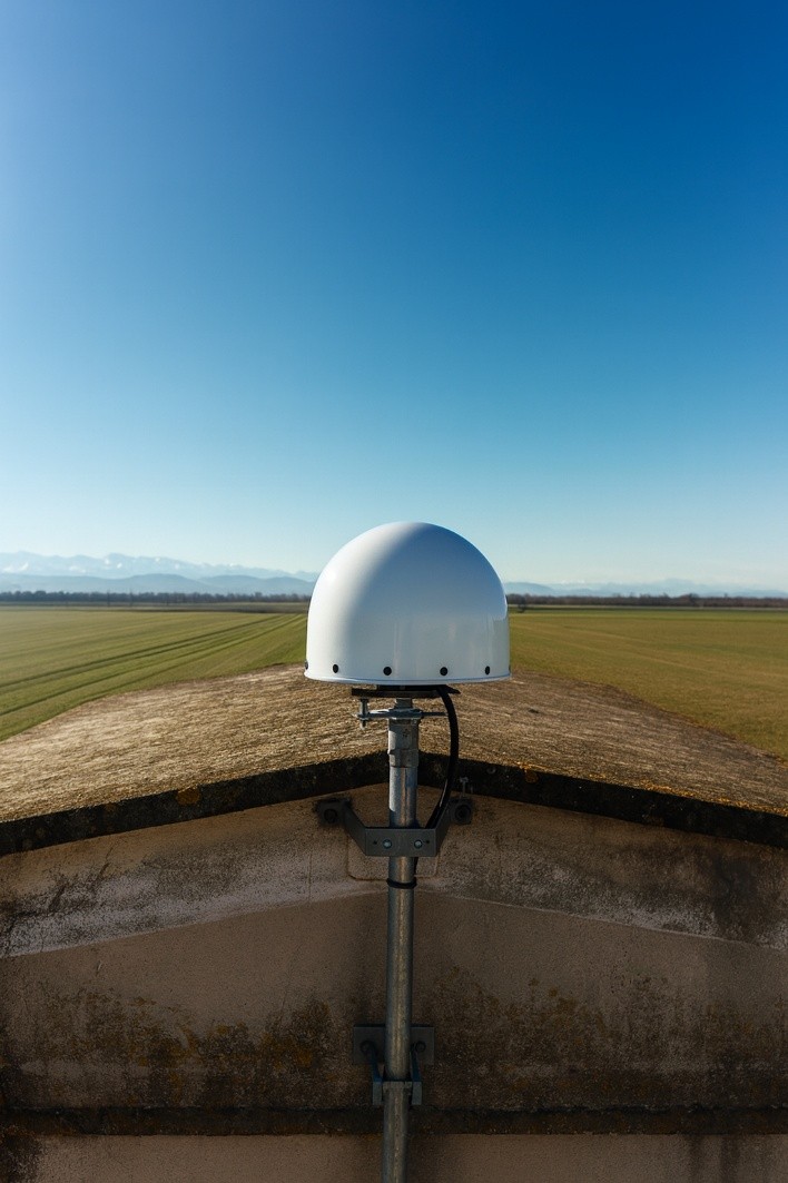
✅ TERIA geodesic station standards
- Concrete structure
(thermal and mechanical stability) - Appropriate foundations
(prior geotechnical study) - Calibrated geodetic antenna with choke ring
(Leica, Trimble, Septentrio…) - Professional anti-vibration mounting
- Protection against multipath (open environment)
- Redundant network infrastructure (NRTK with double stations, not simple RTK)
The TERIA approach: rigour at the service of your precision
Rigorous site selection
Before any installation, each candidate site undergoes an in-depth geological study. Our teams analyse the long-term stability of the soil and assess the structure and type of buildings that are likely to house a station. This analysis is systematically validated by our engineers before any siting decision is taken.
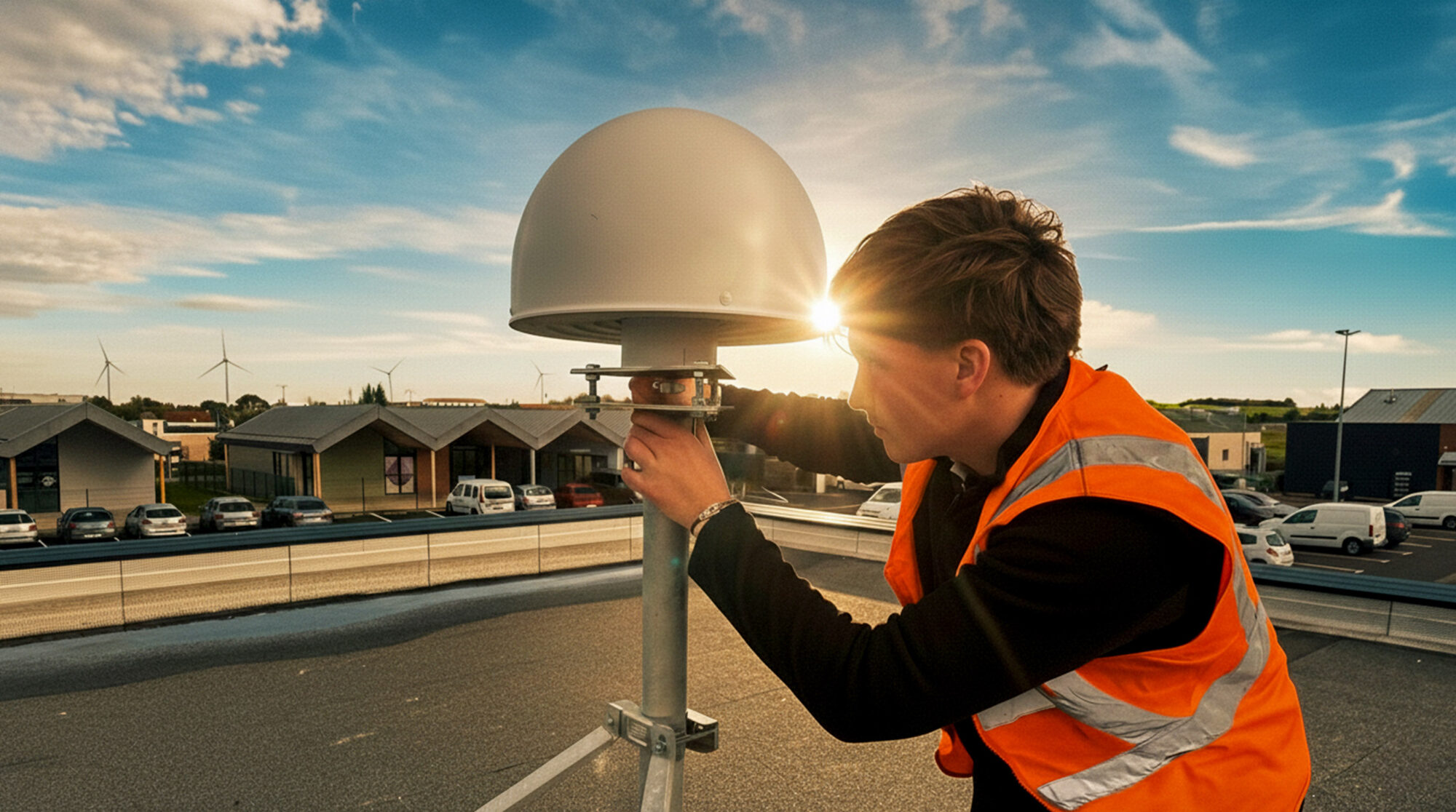
Professional installations
Once the site has been validated, the installation itself meets exacting standards. TERIA deploys only geodesic-quality GNSS antennas with optimum phase centre stability. The anti-vibration mountings have been tested in the field, and the anchors are designed to withstand the most severe weather conditions. Each station benefits from optimum protection against multipath, thanks to a clear, controlled environment. Finally, the architecture is based on a true NRTK network, with each station doubled for safety, guaranteeing continuity of service even in the event of a one-off failure.
Field-proven resilience
All these measures combined enabled TERIA stations to withstand cyclone Chido, which devastated Mayotte in December 2024 withwinds exceeding 220 km/h. Despite the exceptional scale of this disaster, all our stations remained intact. They were immediately operational as soon as the power grid was restored, enabling surveyors and other professionals in the region to resume their activities as quickly as possible– an essential asset for supporting reconstruction efforts.
Permanent 3D monitoring
The quality of a station cannot be decreed: it has to be checked on a daily basis. That’s why TERIA conducts daily stability analysis campaigns along three axes (North, East, Up). This monitoring is carried out in close collaboration with IGN, which calibrates the stations and validates the corrections applied. Any deviation, whether planimetric or altimetric, triggers an automatic alert and rapid intervention by our teams. All movements are traced, archived and available for consultation, providing total transparency on the behaviour of each station in the network.
Total transparency
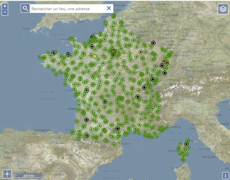
All TERIA stations can be observed in real time via the iTERIA application or on the IGN’s Permanent GNSS Network(RGP) website, to which TERIA is the leading contributor of geodetic data. You can consult the status of each station and check their behaviour for yourself.
TERIA is the only French network to be certified ISO 9001 and ISO 14001 by independent external bodies. This certification validates the monitoring, maintenance and continuous improvement processes that guarantee the long-term quality of the service. Unlike the internal controls practised by some operators, ISO certification commits TERIA to measurable levels of quality that can be verified by a trusted third party.
“TERIA is one of the historical partners of the RGP. TERIA is now the largest contributor to the RGP, representing more than 40% of the stations. “
Votre responsabilité professionnelle mérite un réseau fiable
When you’re signing a recolement plan, installing engineering structures or demarcating cadastral parcels, you can’t afford to doubt your reference data.
The three-dimensional stability of CORS stations is not a technical detail: it’s the basis for guaranteeing your accuracy.
A vertical movement of just a few centimetres, however slight, is enough to compromise the integrity of your surveys and engage your professional liability.
The consequences of an unstable station
When you set up, harvest or deliver a plan, your responsibility is engaged.
An unstable station can result in :
- Systematic errors that cannot be detected in the field
- Offsets on site (wrong locations, conflicts with existing installations)
- Costly rework (re-measuring, modifying structures)
- Disputes with clients, local residents or insurers
- Calls into question your professional civil liability
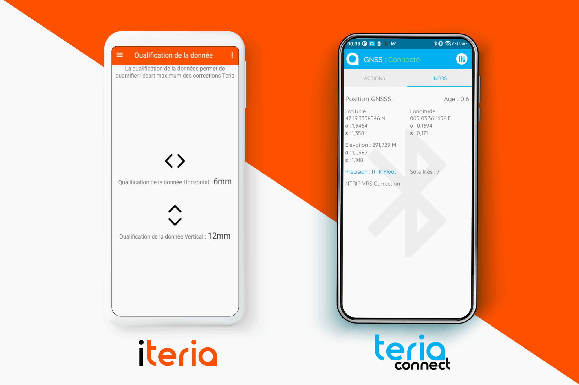
TERIA launches real-time data qualification
To support you even further, in 2025 TERIA launched two levels of data qualification for users of the TERIA network and PYX and DELTO solutions, accessible via the iTERIA and TERIAconnect applications.
Consult your absolute accuracy in real time, including: the instantaneous quality of the GNSS signal, the health of reference stations, any geodetic drift, and ionospheric and tropospheric effects.
The result: fully transparent, conscious control of your work.

Did you enjoy this article?
Feel free to share it.